Published on [Permalink]
Posted in:

Michael Bogdanffy-kriegh—who is always worth reading!—has a good post today on the impact of some recent reading on his exercise patterns. I wanted to highlight one part to make a point somewhat unrelated to his own:

I have decided to focus on getting out of the house and going for walks (mind, body, earth, sometimes community) and winding up at local coffee shops, where I can have direct human-to-human contact (definitely community). Even if that contact is superficial banter with a barista whose name I know and who knows mine, it’s better than the social media app stand-ins we are plagued with. Even if I know no one, and talk to no-one, I am in a space alive with people interacting analog fashion. So that’s it, the coffee shops are my analog version of social media apps. They are way more satisfying.

This sounds lovely and it’s something I would like to do. However, we have a problem in my little town when it comes to walkability or even bikeability.

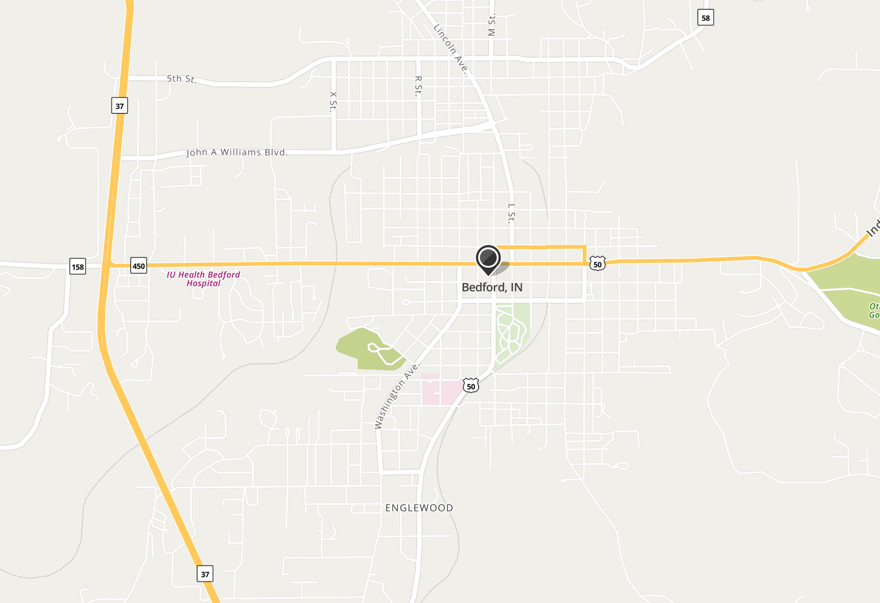
Take a look at this street map. The first thing you need to know is that Highway 37, the main highway on the west of the map, was built as a new terrain road in the seventies. The old highway 37 had a different route. My understanding of the development of that route through Bedford—which has been confirmed by three helpful posts 1 2 3 by Jim Grey—is as follows:

You can see these streets on the map above by looking for the largest north/south streets—and notice that they pass straight through the middle of town. I will say I’m a little surprised that it left town by way of Washington Avenue instead of Mitchell Road but Jim Grey has done a lot more research than I have so I’ll take his word for it. But, in any case, that’s beside the point for now.

You can see from the street map that the streets are clustered around those north-south routes and downtown. Walking and biking—I can say from a lot of experience—is pretty easy around that cluster of streets, so long as you understand that Bedford drivers are not overly concerned about pedestrians and are almost oblivious to cyclists.

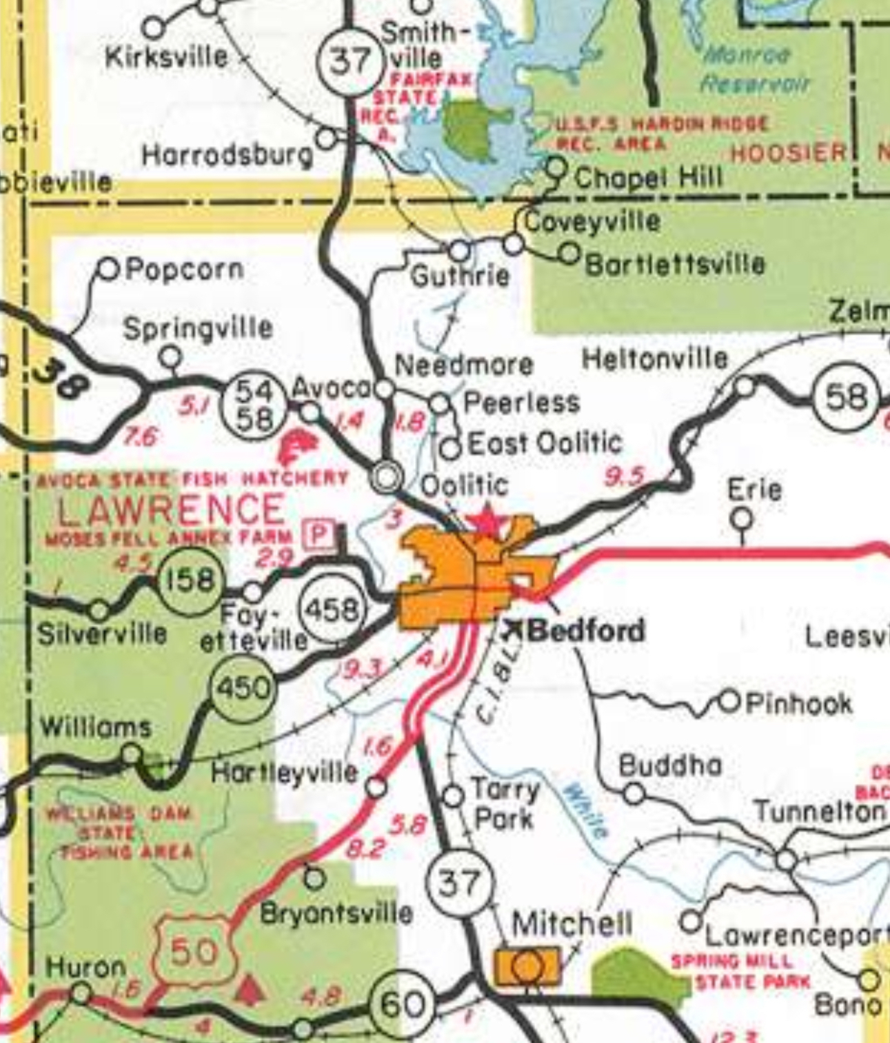
Then came the seventies. Much as I love that decade for its movies and music, it created a real problem for Bedford with the building of “new” Highway 37.

Snip of INDOT highway map for 1970, showing the old highway taking the route described above:

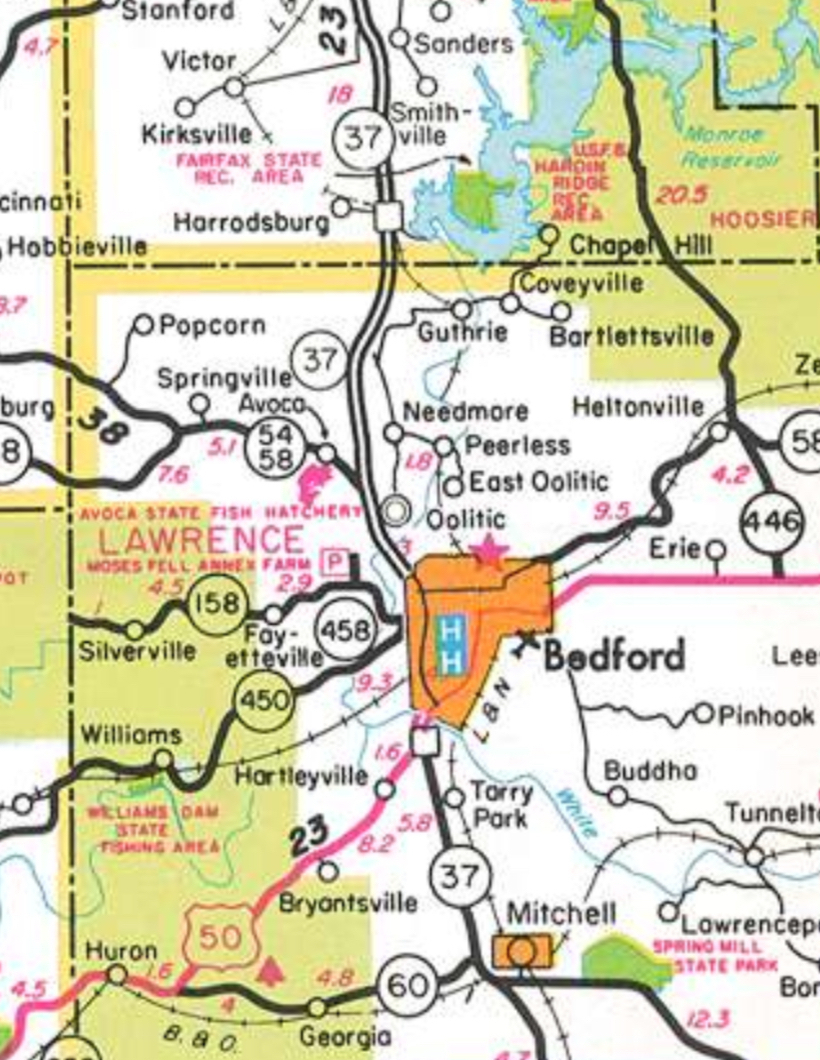
And then a snip of the INDOT highway map for 1980, showing “new” Highway 37 passing just to the west of the bulk of the town:

This is why you see in the street map at the beginning of this post that there are three legs extending from the heart of Bedford to “new” Highway 37, i.e., 5th Street, Williams Boulevard, and 16th Street. Because of their connection to Highway 37, these three streets have been the site of most of the development efforts for the last forty years (apart from an effort by Mayor Shawna Girgis a few years ago to revitalize downtown, which did some real, if temporary, good).

And so, with the building of the new highway, downtown withered. Bedford was distended toward the new highway to the west and no subsequent, large-scale development efforts were made to build infrastructure to network and incorporate those roads. Today this means that, starting from downtown (where I live), there is not a network of quieter, safer secondary roads to get to the more developed west side of Bedford on foot or bicycle.

Starbucks is on 16th Street near the highway. Even with the drive-through a shambolic disaster, it stays very busy. There have been other efforts to open local coffee shop competitors but they haven’t lasted—partly because they were downtown and partly because they didn’t have drive-throughs (this is Rachel’s theory and I think she’s right).

It’s not news that cities have been designed for most of the twentieth and twenty-first century around cars. It’s obvious in my town that little attention has been paid to the movement of pedestrians and cyclists through the town. It’s also obvious that the planners for “new” Highway 37 in the sixties and seventies had little regard for what impact the highway would have for the pattern of life in the towns on the route. (And no regard whatsoever, I’m sure, for nonhuman life when they built it as a totally new road.)

So, yeah, I have no new insights here. Just an illustration of how short-sighted planners, who care only about economic impact and disregard human and nonhuman needs for movement, can cause everything from inconveniences to genuine problems, cascading across generations.

✍️ Reply by email

✴️ Conversation on Micro.blog

jabel

@JohnBrady There really are some good ones. Needmore. And Buddha—which is pronounce booty! And Oolitic is pronounced “o-lit-tick”, despite the double o. It’s funny that you call East Oolitic a suburb, especially if you could see it. It’s always had the reputation of being the rough side of town. My father-in-law grew up there.

Jandy Hardesty

This is the backstory of Pixar’s Cars - and a big reason I love that movie. It may be a minor point in the movie, but the loss of America’s 1950s small towns to the highway/interstate system is something I feel deeply even though I’m not old enough to remember it. I mean, I probably have rose colored nostalgia glasses, but I love small town downtowns and not freeway exit strip malls.

jabel

@faithx5 I agree. Human scale seems to have been forgotten during that development boom.

Jandy Hardesty

@JohnBrady When I moved from St Louis to Los Angeles about fifteen years ago I drove out on old Route 66 as much as possible (it went through St Louis to Santa Monica). Sometimes this was basically a service road, sometimes a lovely detour through a small town, though most were decrepit by then and not cute, unfortunately. Sometimes it was impossible and you just had to drive the interstate. Still glad I at least tried to do it.

Denny Henke

@faithx5 Thanks for writing this! We need more of these kinds of explorations/discussions of car-centered development and the impacts it has had and continues to have on towns and communities. But on the upside it gave us strip mall culture and architecture! Yikes.

It's an old story but worth calling attention to the many, many downsides we've accepted in our bargain with car-centered transport. Looking at the big picture of development in the US over the past 70 years it seems so inevitable and perhaps it was.

Perhaps we can begin to find a different way going forward. We certainly have some amazing examples being created in European cities, especially those in the Netherlands.

I live 8 miles from a smaller town of around 4,500. It's clung to some of it's small town culture and farming roots though in general I don't consider that a positive in terms of politics and general progress towards human rights. But it seems a common cultural thread for many of the small towns that survive in rural America... another subject entirely!

jabel

@Denny It's a love/hate relationship I have with this small town, that's for sure.

David Walbert

And even when planners mean well the process is plagued by unintended consequences. Some decades ago Raleigh decided to "revitalize" part of downtown by closing off traffic and making a pedestrian mall... and made a perfectly walkable desert. Because you had to drive to get there, and then you couldn't park; it didn't connect to anything. A town is much more like an organism than a machine, and ultimately the only way to fully control an organism is to kill it.

jabel

@dwalbert Yes! That's a very important point.

Jandy Hardesty

@Denny It’s probably a combination of things! I think car culture as it led to interstates/etc is probably a symptom of both hurry and individualism. We’d have to address those - lower them in our collective hierarchy of values - in order to meaningfully change car culture and its negative aspects.

Jandy Hardesty

@dwalbert Yes, attempts to do this now have to incorporate parking structures at the outset or it’s a no go. Or some kind of parking/shuttle system, but even then not everyone will want to use that. Because revitalized downtowns have become someplace to GO, not someplace to BE. That said, small towns always had a “someplace to go” aspect because of farmers, etc. There’s probably some nuance to the kind of “walkable” areas we look for now in cities versus the small town historically. (I’m thinking about this out loud right now and “whatabout-ing” myself, lol.)

David Walbert

@faithx5 It’s true, you used to have to park your wagon or your buggy someplace! And people in the 19th century complained about dangerous hansom drivers, not to mention the manure in the streets. But downtowns do feel more like destinations now than hubs, especially in small towns. Maybe there is a path back to being a hub, but I don’t know.

David Walbert

Have you ever read A Pattern Language by Christopher Alexander et al? Exploring principles of design, from towns down to rooms. I should read it again, probably, but it speaks to some of this in a really thoughtful and intriguing way.

Michael Bogdanffy-kriegh

thanks for the shout out! I am fortunate to be located in a small city, less than 20k residents, that is very walkable with a bunch of different options for walks both in town and in nature. It’s less bikable if you are trying to go any distance as it is bounded by busy roads with 45-50 mph speed limits and narrow shoulders. There is where we can use some improvement, whih is coming in the form of rail trails.

jabel

@dwalbert I'm not familiar with it but it does look interesting.

jabel

@mbkriegh We do have a rail trail, which is nice--and would be even better if it had more access points.